Initial Design
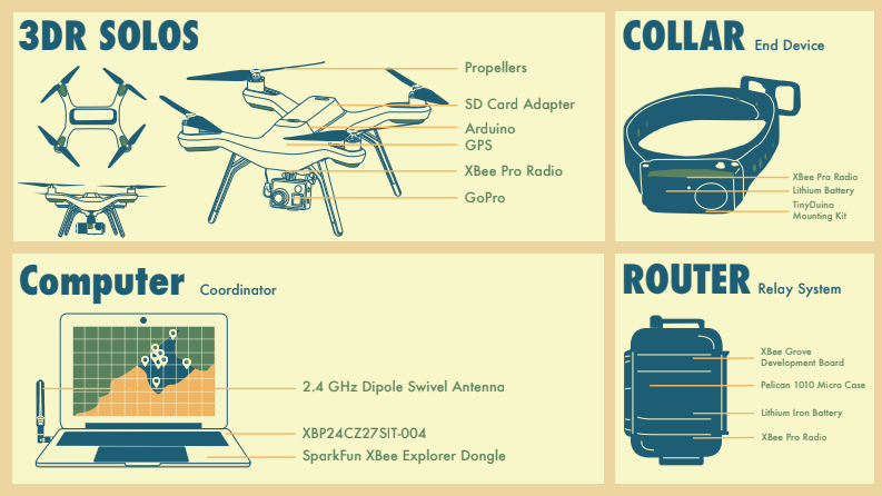
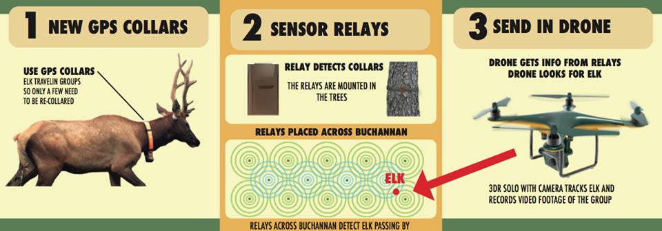
Our initial design concept involved using a 3DR solo drone, GPS collars, a router, and a computer. The elk are collared with something called a gps xbee. As the elk move throughout the different areas of Buchanan, the team will have already placed several gps relay systems that will be able to detect the collared elk as they walk by. The relay system will have something called a raspberry pi attached to it that will serve as a communicator to send the gps signal to another server. A drone will then be flown over the relay area at a given time interval to fetch the gps data. Following that, the drone will send the data back to the database system so that it will have the GPS, time stamp, the specific animal ID, as well as a pin map of pinged locations. The drone will then fly over the specific location to take visuals with a GoPro and then will fly back with the imagery. Below is a detailed step-by-step instruction of our initial method.
1) Test the distance the relay system can track by using a mock GPS and XBee router collar.
2) One member will go out into the forest with the mock collar.
3) The member will walk by the relay system, which also has GPS capabilities and an XBee that will be able to detect when the member walks past it. A raspberry pi will also be placed in the router. This will function as a server that communicates to another server at JMU.
4) The drone will fly across the area and hone in on the location, using the GPS frequency.
5) The drone will broadcast the GPS data back to the main computer database system. The database will contain these GPS/time stamp/animal ID logs as well as produce a pin map of pinged locations on Mission Planner.
6) The drone will then sweep the area with a GoPro to record the journey.
7) We will then see how well the drone’s recording went and if we can identify the member that was tracked in the forest.
8) Drone is piloted to pinged locations to take imagery with GoPro attached to a Gimbal stabilization device.
9) Drone piloted back to base for receiving imagery.
Experiments & Results
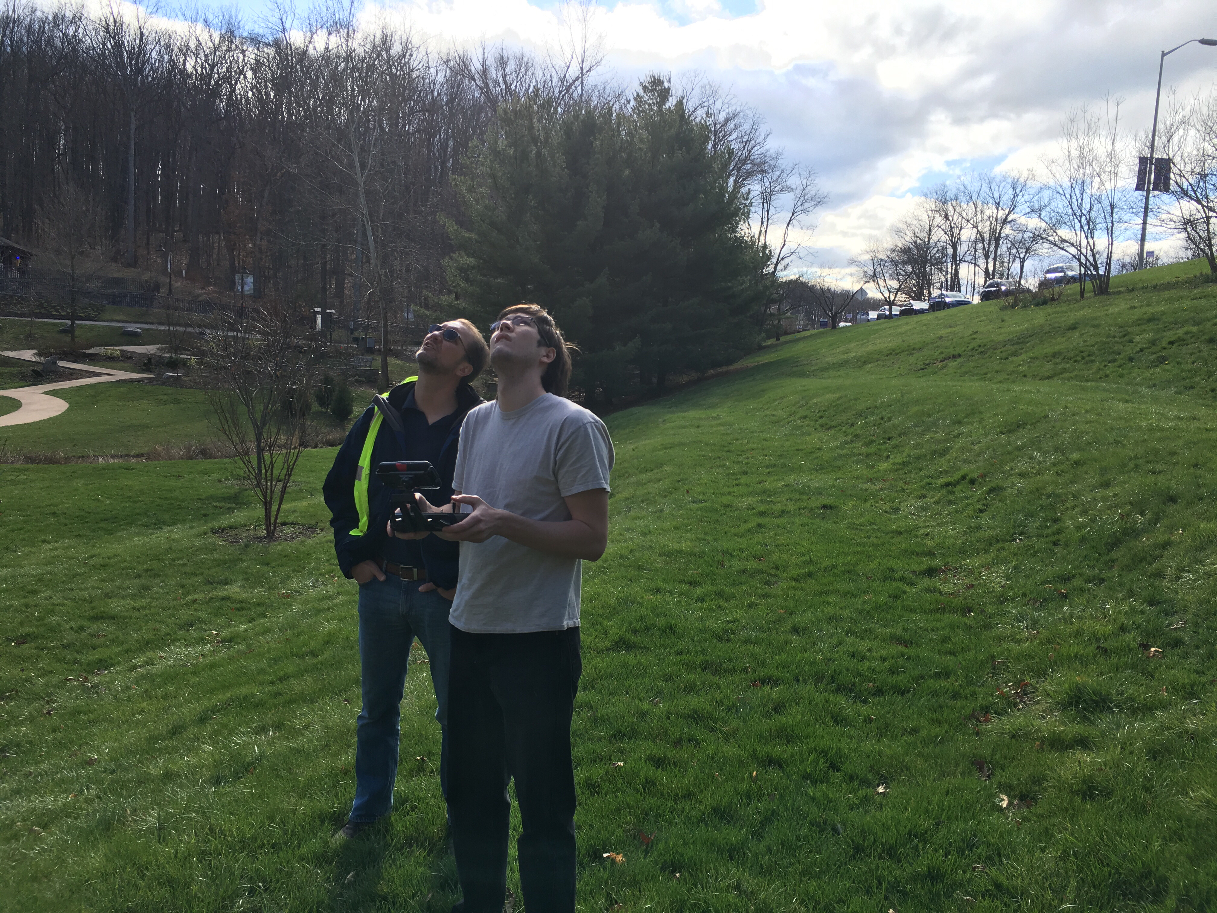
We conducted two field experiments using technology that we planned to incorporate on our drone. The first test was conducted at Purcell Park in Harrisonburg, which is mostly open grassland. Our main goal was to test how high we could get the drone up in the air to test limits of elevation as well as wind. We used a 3DR Solo drone, which at the time was in our initial design concept. We also tested how well the drone could fly within the wooded areas. Each team member got the chance to carefully fly the drone throughout the treeline with no damage done to the system. This experiment resulted in the team understanding how to navigate a drone as well as test the boundaries of how high the drone can be controlled in the air.
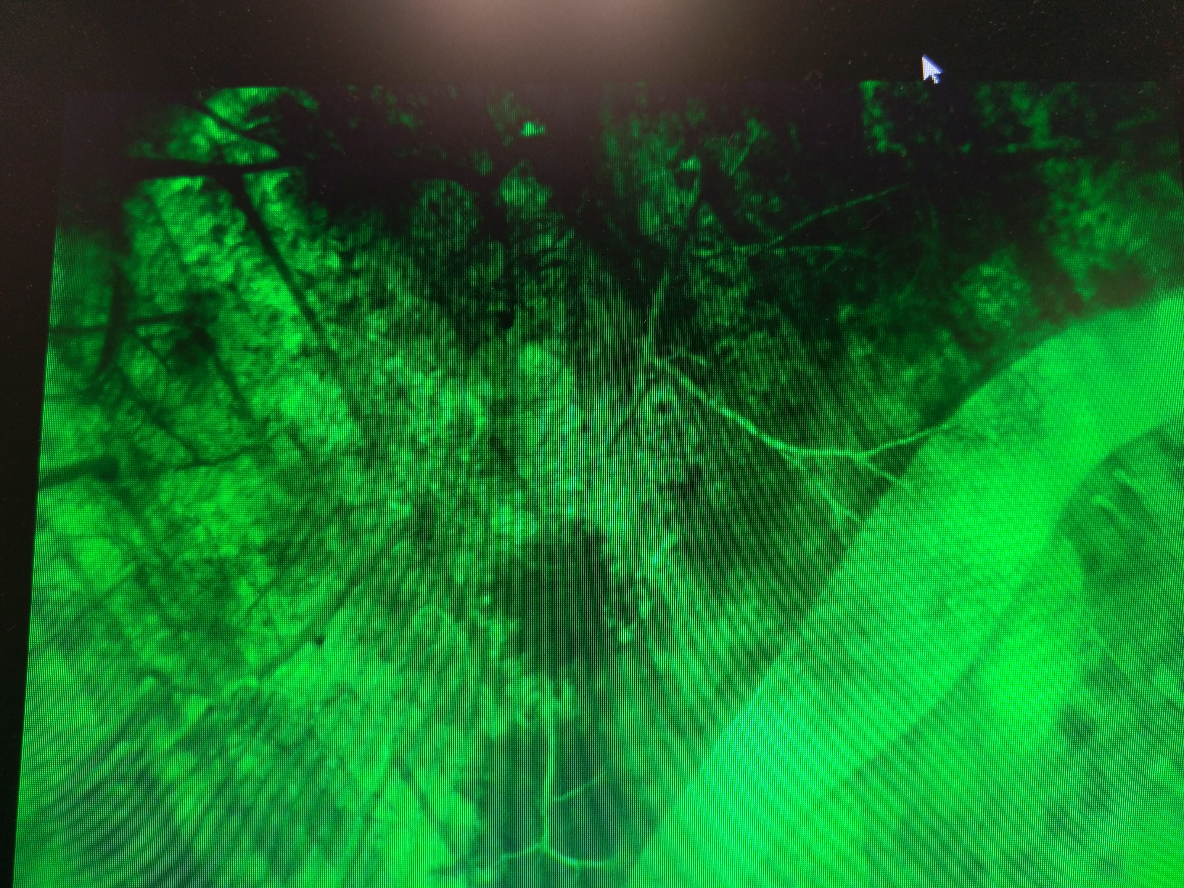
The second experiment we conducted focused on testing thermal imaging technology above a heavily foliated area. For this test, the team went with aviation pilot, Asa, to JMU’s Arboretum, which is a park on campus that is surrounded by trees. We attached a thermal lensed camera to the drone and had team members scatter throughout the wooded area to see if their body heat would be detected from the camera. We were able to depict each member from 250 feet above the ground. It was not until the drone reached around 350 feet when the camera was unable to detect the team members.
Final MVP
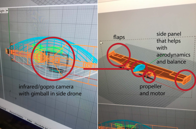
This is the looks like drone, it is a fixed wing drone that uses VTOL (vertical take off and landing). The drone does this by resting with the propellers facing the sky, and the propellers pull the drone up into the sky. One it is at the correct altitude, the drone flips down to horizontal and then flies forward.
https://www.youtube.com/watch?v=PZNx9Y7lq48
This is a link of how VTOL looks. Fred worked on this drone
Future Directions
Currently, our drone was created for VDGIF specifically for locating and tracking elk in buchanan, but we designed this drone in a way that could be used for any type of surveying and locating. We created this drone as a fixed wing so that it can quickly scan areas of land and take footage of the area using a gopro and then uses a flir infrared camera to identify what is beneath the drone.
Basically, we see this taking a future direction of being used for any type of surveying, whether that be for animal conservation or even just to get footage of land for real estate, videography, and more. The gimball stabilizes the camera for a smooth recording.